In January we had to make an unscheduled trip to this
area for a memorial service. I certainly
don’t mind flying back to the area again, Anne went along even though this
isn’t her idea of fun.
Tuesday 3/12. No one in Wheels was available to take us to
the airport, so we hailed an Uber. The
driver is from New Hampshire (he reassured us he was properly registered) and
we had an interesting discussion on how cold Franconia was, what “color” is
good for LED bulbs, and an alternative way to get to the airport.
The Premium Plus seats in this 787-10 have a width of 19”
and a pitch of 38”. Together with a leg
rest and a foot rest they offer reasonable comfort for a transcontinental
flight. Each seat gets its USB and AC
outlets, although placement in the back makes them a bit difficult to access;
there is room in the front of that same recess, wonder if there are technical
reasons for the location.

Three rows of seats are marked "Premium Plus." The lady in front of us carried two small dogs on board, and there was a baby behind us. No issues from either during this flight.

With a seat width of 19", a pitch of 38", I certainly could get comfortable on a transcontinental flight.
The TV screen is quite large. I watched one movie (X-Men: Apocalypse) and couldn’t find much else interesting to
watch. The service was definitely
Economy-grade. My meal was barely warm
(at least it was free.)
The flight was relatively short, a bit over 5 ½
hours. I was surprised at the large
number of Global Services passengers for this flight.
On arrival, we took advantage of our Priority Pass and
ate at SF Giants Clubhouse.
Rental car was from Budget via Costco Travel. The train wasn’t working, so we took the bus
to the car rental center. It was after
11 pm when we checked into the hotel. Hotels are expensive in this area, good
thing I had enough Marriott points for this hotel.

Our rental car, a Toyota Camry, has the Apple Car Play feature. It makes navigation much easier.
Accommodations: Courtyard Livermore (3 nights).
Wednesday 3/13.
Today was Point Reyes Lighthouse day.
From Livermore it was about a two hour drive to the Lighthouse. We were ready to take the 300 or so steps
from the parking lot to the Lighthouse, but once we got into the Park areas
there were signs saying the Lighthouse area was closed. It was under repair and wouldn’t reopen until
early summer. We counted on surrounding
areas to be open, it would be silly to turn back after having driven for over an
hour.
Along Sir Francis Drake Road, close to the Park, traffic
was stopped as a crew tried to make an emergency repair to a huge sink hole in
the middle of the narrow road. We were
told it would take 40 or so minutes, so we stopped by Tomales State Park (which
charged a $7 admissions fee) and visited the “Heart’s Desire Beach.” Eventually we got through the road, covered
with several inches of water. All we
could do was to walk around the area, and tried to enjoy the rugged vistas all
around us. It was a balmy 55F or so, yet
we still needed our light down jackets because of the strong wind.
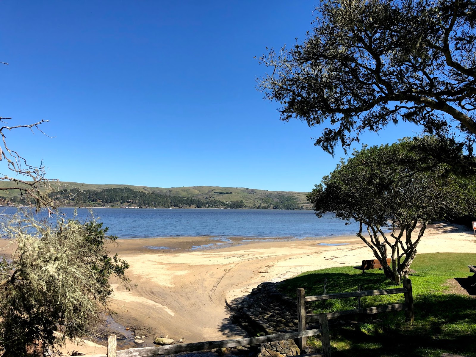
Heart's Desire Beach in Tomales State Park.

This part of The Point Reyes National Seashore has a shore line of about six miles (per Google maps.)

The Cypress Tree Tunnel was planted around 1930, per nps.gov.
 The strong winds in the area also have been building up high sand dunes such as this one.
 Elephant seals resting on the beach (zoom in to notice the snouts characteristic of such animals).


We stopped by the IHOP in San Rafael before heading back
to Livermore, starting at around 6 pm.
Traffic was lighter than expected.
Total driving distance: about 200 miles.


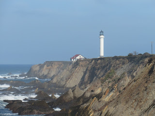
Point Arena Lighthouse has a tower that is 115' high.
Thursday 3/14. Last night Anne saw this news article about
spring flowers and butterflies that may be in the area. Indeed we found a website saying the best
wild flowers can be seen at two locations in Point Reyes (we missed them
yesterday), Mount Diablo, and two in an area south of Livermore. Since we had visited Mt. Diablo before, we
decided to take a route that would take us to Del Puerto Canyon Road and Lick
Observatory. We did see patches of
yellow, orange, and purple flowers, not quite in full bloom, and a few butterflies. Southern California may be teeming with
millions of painted lady butterflies now, but no a lot have made it up this way
yet.
The path takes us from Interstate 5 to US101, over CA 130. This was probably one of the
longest stretch of winding road I have driver over: about 60 miles, taking 2
hours. We started late, around 11:30 am, and needed to be in South San
Francisco by 4 pm, so we ended up not making too many stops. I did the white-knuckle driving, and Anne
pointed out some interesting sights along the way.
We did stop at the Lick Observatory, a University of
California property. We had to wait for
the rock slide on CA 130 to be cleared, so took advantage of that to use the
restrooms at the Observatory (so nice of them to make them available to people
passing by.) Anne took a look and said
the facility is quite impressive.

Most of the area of bloom are on the mountain sides.

We saw this patch of poppies on the road side.

There are also many rapeseed flowers along the way.


Anne took a quick look inside the visitor center.

Except for the occasional telescope and signs asking drivers to be quiet as people sleep during the day, this is like many small towns we pass by during the trip.

San Jose in the distance as we drive down from Mt. Hamilton. Notice the winding road.
In any case, we made it to South San Francisco in time to
meet up with Bill and Louisa. Louisa
again prepared an early dinner for us.

Meeting up with Louisa and Bill.
The drive to Davies Symphony Hall was quite
straightforward, but the Performance Garage was full (one needed advanced
reservations.) Luckily we found
off-street parking for free a block away.
This was our first visit to the concert hall, and we
enjoyed the performance by the San Francisco Orchestra, led by Michael Tilson
Thomas.

Davies Symphony Hall is located in the Civic Center area of San Francisco. Behind me is City Hall.

Michael Tilson Thomas and the San Francisco Symphony.
It was a bit after 11 pm when we got back to the hotel.
Total driving distance: about 220 miles.

This is the route we took. CA 130 is quite a challenge.

This is a particular winding stretch on CA 130.
Friday 3/15. Today’s plan was to drive up the coast along
Highway 1 to get to Point Arena, and stopping by a few vistas to admire the
rugged California coast, and to visit Bowling Ball Beach – I found out about
that from a Microsoft Windows screensaver – and Point Arena Lighthouse.
I somehow had erroneously thought it would take 2 ½ hours
to get to Bowling Ball Beach. As high
tide today at Point Arena was going to be around 1:30 pm, leaving Livermore at
around 11 am should give us a lot of time.
Well, we didn’t leave until about 11:30 pm, and the drive was going to
be 3 ½ hours, not counting any stops we had to make.
There were some winding sections, although our drive
yesterday gave us some practice. Along
some stretches there were few houses, but we did drive through some small
enclaves along the way such as Bodega Bay, Jenner, Sea Ranch, and Gualala. We passed by many areas with breathtaking
scenery, but were in too much of a rush to stop to enjoy the view, and I had to
concentrate on the road ahead of me anyway.
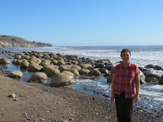
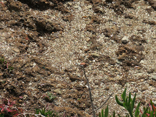
All said and done, we got to the Bowling Ball Beach area
at around 3:30 pm, and went down the “wrong” path (it would have involved
scrambling over some rocks that we were ready to do.) By the time we used the “north path” at the
parking lot, walked down a rather steep set of wooden steps, scrambled across
some deadwood, and jumped over two small streams, it was about 4:30 pm when we
got to the Beach. Even though the tide had come in about half way, there were
enough of these round rocks on the beach that it made the visit quite
worthwhile.
Bowling Ball Beach. We got here more 2 hours after low tide, but were able to catch these round rocks.
Waves lapping at the bowling ball rocks. Supposedly they will be mostly submerged at high tide.

To get to the beach we had to scramble over some dead wood strew across a stream ...

... and ford some streams.
After checking in at our hotel for the night, we headed
to the beach to have dinner at Chowder House, our most expensive meal so far
this trip. It was a little after 7 pm when we were done, so we drove to Point
Arena Lighthouse to take a look. The
sunset (behind clouds in the horizon) was still quite nice.

We had dinner at Chowder House, Anne had the Ling Fish, ...

... and I had scallops and beef.

Wharf Master's Inn looked great with the setting sun. Our room had a partial view of the ocean.

Beautiful sunset colors down at the wharf.

Total driving distance: about 175 miles.
Accommodations: Wharf Master’s Inn, Point Arena (1
night.)


Accommodations: Best Western Plus Humboldt Bay (2
nights.)
Total driving distance: about 200 miles.


Saturday 3/16. Continental
breakfast was served at the Inn beginning at about 8 am. We started our day from the hotel at about 10. We first drove to the Point Arena Lighthouse
again to take a few pictures. There was
this Redtailed Hawk that flew from telephone pole to pole, we think it was
sick. We decided not to climb this “tallest
lighthouse” on the West Coast.


Point Arena Light during the day.

This red tailed hawk flew from post to post. It was probably hurt. There are many red-tailed hawks in the area.
Our next stop was the Point Cabrillo Lighthouse. With a tower at 47’, it is considerably
smaller than that of Point Arena Light (at 115’). The walk from the parking lot down was a
little over ½ mile. We took some time to
enjoy the rugged coastline, and saw this seal sunning itself.


Point Cabrillo Lighthouse.

The headlands around the lighthouse.

This harbor seal was sunning itself.
Fort Bragg is one of the larger towns along the way, and
we stopped by Cucina Verona for a quick bite.
Lunch specials cost only $8, and the portions were substantial.

Each of these lunch specials (chicken fried steak and eggs; fish sandwich) cost only $8 at Cucina Verona in Fort Bragg.


Townspeople used to dump all their garbage on some designated beaches. Non-biodegradable junk was removed and what remain are shard of glass and pottery. Collecting of these items are prohibited.
California State Route 1 is known by various names such
as Pacific Coast Highway, Shoreline Highway, and Cabrillo Highway. A lot of it is winding and hairpin turns,
including the stretch from Point Arena to Leggett. Our drive on Route 130 gave me good practice. The highway terminates in Leggett and joins
up with US 101.
The tourist attraction (or trap) is the Drive-Thru Tree;
it costs a very reasonable $10 per car. We
saw many SUVs got close to the tree and then the drivers decided the hole wasn’t
large enough for their cars to go through.
Our rental Camry did that with a little room to spare (better with the side
mirrors folded in).


Wide enough for our rental Camry to drive through.

2400 years old, 21' diameter, 315' tall.
The Avenue of the Giants is an old stretch of US101 (now
called CA 254) of about 30 miles long.
There is a guide one can pick up that explains the eight recommended
stops along the way. We drove from the
Southern Entrance to the North Entrance, stopping briefly at each of the
stops. The Coastal Redwood common in
this area is the taller than the Giant Redwood (height of 370’ vs 300’) but not
as massive. However, as we were driving
on the road lined by these trees, they were massive enough. Even though the sun was out, their canopies
blocked out most of the sun.


This trunk at the Humboldt State Forest Visitor Center was from 912 AD to 2006 AD. The Vikings discovered America around 1000 AD, and the California State Park System was established in 1928.

I do not know how to capture the grandeur of these trees. This was taken with iPhone's panoramic mode.
 Another photo of redwoods.

It was about 7 pm when we checked into our hotel. Dinner was at Café Waterfront, recommended by
the front desk.
I must confess to more confusion. Fort Bragg is not the military base in North
Carolina, and President Reagan went to Eureka College in Indiana. There is no Eureka College in Eureka.
Total driving distance: about 180 miles.
Sunday 3/17. After
having breakfast at the hotel, we headed out to the Arcata Marsh Interpretative
Center. There were quite a few birds,
most of them common, but we did see a large flock of Godwits. We spent a bit of time walking around the
Butchers Slough Log Pond.


Eureka hosts a Godwit Festival in April. These got here early. Mixed in were some other birds.
We went back to Arcata Marsh at around 6 pm. It was low tide and the godwits were gone. However, this bird (sparrow-like) was singing his heart out.
There were quite a few references about the Samoa Cookhouse which started as an eating place for laborers in the area. For today it was corned beef and cabbage (appropriately enough).


The Samoa Cookhouse is family style version. All you can eat, and for today it was Corned Beef and Cabbage (lunch and dinner).

There is an interesting collection of old mechanical instruments such as cash registers and typewriters.
It was then driving up the coast along US101, which is much
easier to navigate than what we had to do the previous couple of days. We stopped along the way for rests, short
walks, and views.


Photo taken in Redwood National and State Park.
Trillium Falls is about 0.5 mile from the Elk viewing parking lot.

Typical North California coast line. Note the low clouds.
Up close.
Roosevelt elk come down to the meadows and are supposedly
easily spotted. We did spot a few, and
there were some herds kept that were easily seen from the road.


A couple of Roosevelt Elk foraging on a meadow.

These were raised by local farmers.
We drove all the way to Crescent City before making our
way back to Eureka.
Monday 3/18. Our trip was coming to a close. Our
objective for the day was to drive from Eureka to Santa Rosa, where we would
stay for the night before heading out to the airport for our 2 pm flight
tomorrow. Per Google Maps, the trip was
224 miles, and should take about 4 hours.
Somewhat like our drive to Boston.
Most of the driving would be on US101, which should be much better
compared to CA 1.
We did a couple of detours that added perhaps 15 miles to
our trip. First was to Woodley Island
where most of Eureka’s fishing fleet is docked.
If we had gotten there at the right time we would have seen people
buying today’s catch. We didn’t. It was a working pier, but there was a
certain charm to it. There was an
obelisk listing all the sailors that had lost their lives doing their job, and
for quite a few the bodies were not recovered.
There was also a rock commemorating the Native Americans who lived there
before the settlers came.

Eureka still has a sizable fishing industry, these are all working boats moored in the Reach between Woodley Island and Eureka.

Statue of Fisherman and Boat. Quite a few fishermen have been lost at sea. Reminded me of Bellington, WA.

A flock of godwits standing in the water. I wonder if the one on the left, with its curved beak, is a curlew - they are supposed to be uncommon for this area.

There are quite a few well-preserved Victorian-era houses in Eureka.

Lighthouse on Woodley Island.
The entire town of Ferndale has been designated a
historic site, mostly for its Victorian architecture. The town still has many houses with a
Victorian façade. Being a Monday
morning, it was really quiet.

Victorian houses lined the main street of Ferndale. The entire town has been designated a California Historic Landmark.
When we were on our way up the Humboldt Redwood State
Park Visitor Center was closed, we decided to stop by and see if we could learn
anything from the displays inside the Center.
One interesting item was this “one-log” home crafted out of a 20-some
foot section of an 11-foot diameter tree.
It was hauled around to promote conservation by some guy. In any case, near Garberville there is a
one-log home you could go in to visit for $1.
Having seen this one (we could not go in) we decided to skip the
commercial one.

Charles Kellogg's One-Log Home traveled across the country 4 times to bring attention to the need to preserve the redwoods.
During the 100 or so mile stretch of US101 we passed by
very few towns. Laytonville, with a
population of 1200 or so (its declining) was where we had lunch. I must say there isn’t much charm to the
town, although it wasn’t bad either.

Cafe in Laytonville where we had a quick lunch. The town is not as bucolic as one might think.
Our hotel is actually located in Sebastopol, some 10
miles from Santa Rosa. I found Pepe’s, a
Mexican Restaurant on the United App and decided to give it a try. Half the customers (not that many) spoke
Spanish, which hopefully meant it was a reasonably authentic Mexican
restaurant. I enjoyed the taco, relleho,
and burrito dinner. Anne’s beef fajita
was huge, she could finish only half of it.

Sumptuous Mexican dinner.
Total driving distance: about 250 miles
Accommodations: Fairfield Inn Santa Rosa Savestopol (1
night).
Tuesday 3/19. SFO is about 65 miles from our hotel, so we
spent the day getting to the airport.
There is a Costco less than 2 miles from Rental Car Return, so it was
quite straightforward.

Pre-flight snack at the SF Giants Club House, courtesy Priority Pass.
We are again in the Premium Economy, and I am finishing
this up about 30 minutes from touch down.

While the claim is this is done randomly, this was the first time TSA agents (3 of them) were at the boarding gate. One checked my ID, one looked into my backpack, and the third swabbed my laptop. Perhaps I was remarking to them that I had never seen them before?

San Mateo Bridge spanning the San Francisco Bay.

The 787 has these huge engines.
We took an Uber home.
TOTAL distance for trip: about 1350 miles. Not counting tolls, this worked out to a cost
of about $0.30 per mile.